331 ·GitHub
Что это такое?
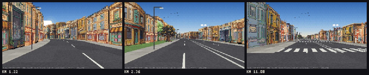
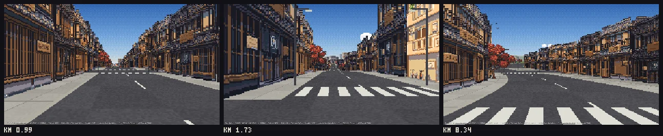
 Pixel Path — это навык Claude Code, который превращает реальный маршрут между двумя точками в пролёт от первого лица в пиксель-арте, с настоящими зданиями, рельефом и ориентирами из OpenStreetMap и данных о высоте.
Это отдельное приложение или то, что работает внутри Claude Code?Это навык Claude Code, а не отдельное приложение: вы устанавливаете его в папку навыков Claude и просите у Claude маршрут обычными словами, а результат — это обычная папка с index.html, которую можно открыть через любой статический веб-сервер.
Это навык Claude Code, а не отдельное приложение: вы устанавливаете его в папку навыков Claude и просите у Claude маршрут обычными словами, а результат — это обычная папка с index.html, которую можно открыть через любой статический веб-сервер.Как мне установить и пользоваться?Установите как плагин Claude Code или скопируйте папку вручную в свою папку навыков, чтобы навык оказался по пути ~/.claude/skills/pixel-path/SKILL.md (или .claude/skills/pixel-path/ для одного проекта), а затем просто попросите Claude построить маршрут, например: «пиксельный путь из Бата в Бристоль».
Установите как плагин Claude Code или скопируйте папку вручную в свою папку навыков, чтобы навык оказался по пути ~/.claude/skills/pixel-path/SKILL.md (или .claude/skills/pixel-path/ для одного проекта), а затем просто попросите Claude построить маршрут, например: «пиксельный путь из Бата в Бристоль».Что нужно помимо Claude Code?Для сборки заглушечного маршрута достаточно Node 18 или новее; для настоящей сгенерированной графики нужен аккаунт RetroDiffusion с кредитами и API-ключ, заданный как переменная окружения; необязательная самопроверка по скриншотам требует Node 20+ с Playwright и Chromium.
Для сборки заглушечного маршрута достаточно Node 18 или новее; для настоящей сгенерированной графики нужен аккаунт RetroDiffusion с кредитами и API-ключ, заданный как переменная окружения; необязательная самопроверка по скриншотам требует Node 20+ с Playwright и Chromium.Каковы главные ограничения?Навык строит только маршруты для автомобилей без трафика, людей и погоды; здания, которых нет в OpenStreetMap, получают правдоподобные угаданные формы и высоты; один регион использует один и тот же набор картинок, поэтому длинные улицы повторяются; а Overpass, источник картографических данных, работает медленно и может выходить по таймауту, так что длинный маршрут может строиться до часа.
Навык строит только маршруты для автомобилей без трафика, людей и погоды; здания, которых нет в OpenStreetMap, получают правдоподобные угаданные формы и высоты; один регион использует один и тот же набор картинок, поэтому длинные улицы повторяются; а Overpass, источник картографических данных, работает медленно и может выходить по таймауту, так что длинный маршрут может строиться до часа.Видит ли навык мой API-ключ RetroDiffusion?Нет, ключ вы задаёте сами — как переменную окружения или в macOS Keychain; навык никогда не запрашивает его в чате и нигде не выводит.
Нет, ключ вы задаёте сами — как переменную окружения или в macOS Keychain; навык никогда не запрашивает его в чате и нигде не выводит.Сколько стоит сгенерировать маршрут?Деньги уходят только на графику — $0,18 за картинку от RetroDiffusion; маршрут на два региона стоит от $0 (заглушки, нарисованные кодом) до примерно $11,16 на детальном уровне, с до 26 картинками на регион плюс ориентиры.
Деньги уходят только на графику — $0,18 за картинку от RetroDiffusion; маршрут на два региона стоит от $0 (заглушки, нарисованные кодом) до примерно $11,16 на детальном уровне, с до 26 картинками на регион плюс ориентиры.Как навык проверяет свою работу перед тем, как отдать результат?Он рендерит контактный лист со всеми сгенерированными картинками, раскладывает весь маршрут, чтобы найти разрывы в стенах улиц, затем проходит камерой каждые 75 метров, высматривая небо, просвечивающее сквозь здания, и просит Claude проверить самые проблемные кадры и перегенерировать плохую графику.
Он рендерит контактный лист со всеми сгенерированными картинками, раскладывает весь маршрут, чтобы найти разрывы в стенах улиц, затем проходит камерой каждые 75 метров, высматривая небо, просвечивающее сквозь здания, и просит Claude проверить самые проблемные кадры и перегенерировать плохую графику.Для чего я могу реально использовать сгенерированный пролёт?Уровни с настоящими дорогами для гонок или бесконечных раннеров, видеоотчёты о поездках и контент о путешествиях, фоны для стримов и lo-fi-музыка на повторе, а также прокомментированный псевдо-3D рендерер и конвейер подготовки данных OpenStreetMap, на котором можно учиться или который можно доработать.
Уровни с настоящими дорогами для гонок или бесконечных раннеров, видеоотчёты о поездках и контент о путешествиях, фоны для стримов и lo-fi-музыка на повторе, а также прокомментированный псевдо-3D рендерер и конвейер подготовки данных OpenStreetMap, на котором можно учиться или который можно доработать.Какие есть похожие проекты?pixelfx, agent-sprite-forge, claude-pxl, gif-factory, rimochan-nyamuru-manga-forge, sprite-gen, shuohao-skills, handraw-style
pixelfx, agent-sprite-forge, claude-pxl, gif-factory, rimochan-nyamuru-manga-forge, sprite-gen, shuohao-skills, handraw-styleВ каких он темах?openstreetmap, retro, pixel-art, geospatial, procedural-generation, maps, skill-md, claude-skill, creative-tools, content-creation, game-development, image-generation
openstreetmap, retro, pixel-art, geospatial, procedural-generation, maps, skill-md, claude-skill, creative-tools, content-creation, game-development, image-generation