terrio reads, writes, converts and reprojects the geospatial formats most workflows use, without
C dependencies, so that it builds anywhere Rust does, including WebAssembly.
Status: early development. The API may change before 1.0. See ROADMAP.md.
terrio builds on the pure-Rust format libraries of
whitebox_next_gen (wbraster, wbvector,
wbprojection) and adds format detection, remote and archived inputs, a GeoTIFF reader built on the
tiff crate, fixes for what the format libraries miss, and
GDAL-style operations. terrio runs without installing GDAL, but it is not independent of GDAL: its
commands and options follow GDAL's, many of its algorithms and drivers are ports of GDAL, PROJ and
PDAL code, and its results are tested against them (see Acknowledgements).
Coordinate transformations match GDAL's: terrio carries the EPSG CRSs with the coordinate
operations GDAL uses for them (generated from GDAL and PROJ by scripts/gen_epsg_table.py) and
pure-Rust ports of the projections they need. For each of the 6,354 EPSG geographic and projected
CRSs GDAL 3.12 transforms, transformations from and to WGS 84 agree with GDAL's within a
centimetre, and 99 % of a sample of transformations between two CRSs within a metre (see
crates/terrio-crs/tests/epsg_accuracy.rs).
Command line
Install the terrio command, a standalone binary, with:
curl -LsSf https://terrio.dev/install.sh | sh                                # Linux, macOS
powershell -ExecutionPolicy ByPass -c "irm https://terrio.dev/install.ps1 | iex"  # Windows
brew install --cask opengeos/terrio/terrio and pip install terrio install it too, and
cargo install terrio-cli builds it from source (see
Installation).
terrio info countries.gpkg                       # summarize a dataset (--json, --stats)
terrio info s3://bucket/image.tif                # remote: http(s)://, s3://, gs://, az://, /vsicurl/
terrio info "archive.zip!dir/roads.shp"          # zip archives, or /vsizip/archive.zip/dir/roads.shp
terrio convert countries.shp countries.gpkg      # convert between formats
terrio convert dem.tif dem_cog.tif -f COG --compress DEFLATE
terrio convert https://host/cog.tif w.tif --srcwin 1024 1024 512 512 --overview 0  # window of an overview
terrio convert roads.geojson roads.fgb --t-srs EPSG:3857
terrio convert countries.geojson europe.gpkg --where "CONTINENT = 'Europe'" --select NAME,POP_EST
terrio info https://host/tiles.pmtiles           # PMTiles read in place (header, then the tiles needed)
terrio info "ZARR:\"/vsis3/bucket/store.zarr\":/group/array"  # Zarr v2/v3 read in place (chunks needed only)
terrio convert landsat.tif landsat.pmtiles       # raster tiles in EPSG:3857, every zoom level (or .mbtiles)
terrio convert countries.gpkg countries.pmtiles --maxzoom 6   # vector tiles (MVT), or -f MVT for a directory
terrio convert counties.gpkg tn.gpkg --spat -90.3 34.9 -81.6 36.7  # through the GeoPackage's R-tree
terrio convert more.shp world.gpkg --append --nln countries          # update an existing GeoPackage
terrio rasterize counties.gpkg pop.tif -a POPULATION --tr 0.01 0.01 --ot Int32
terrio polygonize landcover.tif landcover.gpkg --8
terrio centroid countries.gpkg centroids.gpkg     # planar centroids, keeping attributes and CRS
terrio singlepart countries.gpkg parts.gpkg       # split multipart geometries and collections
terrio vertices roads.gpkg nodes.gpkg             # vertices with source/part/ring/vertex indices
terrio buffer roads_utm.gpkg buffers.gpkg --distance 100  # planar CRS units
terrio overlay parcels.gpkg zones.gpkg intersections.gpkg --operation intersection
terrio dissolve counties.gpkg states.gpkg --field STATEFP
terrio is-valid polygons.gpkg validity.gpkg
terrio make-valid polygons.gpkg repaired.gpkg
terrio clean roads.gpkg cleaned.gpkg --snap-grid 0.01
terrio footprint image.tif footprint.gpkg         # exact valid-data boundary, including holes
terrio sample sites.gpkg sampled.gpkg --raster dem.tif --raster rain.tif  # values at points
terrio contour dem.tif contours.gpkg --interval 10 --3d
terrio zonal-stats counties.gpkg stats.gpkg --raster dem.tif --raster rain.tif --stats count,mean,stddev
terrio sql countries.gpkg selected.gpkg --query "SELECT ADMIN, POP_EST FROM countries WHERE POP_EST > 1e7"
terrio crs EPSG:32610 --to EPSG:4326 699960 3900000
terrio translate dem.tif sub.tif --projwin -105.7 39.8 -105.3 39.5 --ot Int16   # like gdal_translate
terrio translate img.tif small.tif --outsize 25% 25% -r average --scale 0 4000 0 255 --ot Byte
terrio warp dem.tif dem_utm.tif --t-srs EPSG:32613 -r bilinear              # like gdalwarp
terrio warp a.tif b.tif out.tif --t-srs "+proj=lcc +lat_1=33 +lat_2=45 +lon_0=-96" --tr 100 100 --tap
terrio warp dem.tif clip.tif --cutline area.geojson --crop-to-cutline
terrio mosaic tiles/*.tif mosaic.vrt                                        # like gdalbuildvrt
terrio mosaic tiles/*.tif mosaic.tif --resolution highest --nodata -9999   # like gdal_merge.py
terrio dem hillshade dem.tif shade.tif -z 2 --multidirectional              # like gdaldem
terrio dem slope dem.tif slope.tif -s 111120 -p
terrio dem color-relief dem.tif colors.txt relief.tif --alpha
terrio calc -A red.tif -B nir.tif --calc "(B - A * 1.0) / (B + A * 1.0)" --type Float32 ndvi.tif  # gdal_calc.py
terrio fill-nodata dem.tif filled.tif --max-distance 100 --smoothing-iterations 1  # like gdal_fillnodata
terrio proximity roads.tif dist.tif --values 1 --distunits GEO --maxdist 5000  # like gdal_proximity.py
terrio sieve landcover.tif clean.tif --st 10 -8                            # like gdal_sieve.py
terrio info "https://earth-search.aws.element84.com/v1/search?collections=sentinel-2-l2a&bbox=..."  # STAC: footprints, mosaics
terrio convert 'STACIT:"https://.../search?...":asset=red' red.tif --srcwin 0 0 1024 1024  # like GDAL's STACIT
terrio convert dem.tif dem.zarr --co GEOREFERENCING_CONVENTION=SPATIAL_PROJ --co OVERVIEW_LEVELS=AUTO  # GeoZarr
terrio preview dem.tif -o dem.png -c terrain     # PNG or terminal preview (Kitty, iTerm2, sixels, blocks)
terrio view dem.tif -c terrain                   # pan-and-zoom map in your browser
terrio formats                                   # list the drivers

# Point clouds: LAS 1.0-1.4 (formats 0-10, extra bytes, waveforms), LAZ, COPC and EPT (read in
# place, local or remote), PLY, E57; files larger than memory converted in chunks
terrio info tile.laz --stats                     # header, CRS, classes and returns (like pdal info)
terrio info https://host/lidar.copc.laz          # COPC octree depth and points per level
terrio convert tile.laz tile.copc.laz            # LAS <-> LAZ <-> COPC
terrio convert https://host/lidar.copc.laz sub.laz --bounds 637000 851000 637500 851500 --max-level 4
terrio convert tile.laz ground.laz --class 2 --returns last,only --t-srs EPSG:4326
terrio convert tile.laz points.gpkg --dims z,intensity,classification   # to a vector layer of points
terrio grid tile.laz dsm.tif --tr 1 --stat max                          # like PDAL's writers.gdal
terrio grid tile.laz dtm.tif --tr 1 --stat idw --class 2 --window-size 3
terrio grid tile.laz tin.tif --tr 1 --class 2 --method linear           # like gdal_grid -a linear
terrio filter smrf tile.laz classified.laz                              # PDAL's filters.smrf
terrio filter outlier tile.laz clean.laz --remove                       # filters.outlier
terrio filter csf tile.laz classified.laz                               # filters.csf, pmf, elm...
terrio filter hag_nn classified.laz hag.laz                             # filters.hag_nn, crop, normal...
terrio filter colorization tile.laz rgb.laz --raster ortho.tif          # filters.colorization, dem, overlay...
terrio filter covariancefeatures tile.laz f.laz --knn 16                # filters.dbscan, lof, eigenvalues...
terrio convert scan.e57 scan.laz                                        # E57, PLY, EPT
terrio convert tile.laz tile-ept/ept.json                               # write an EPT dataset
terrio mcp serves the commands to AI agents (Claude Code, Claude Desktop, Cursor, VS Code) over
the Model Context Protocol: claude mcp add terrio -- terrio mcp (see
AI Agents).
Browser UI
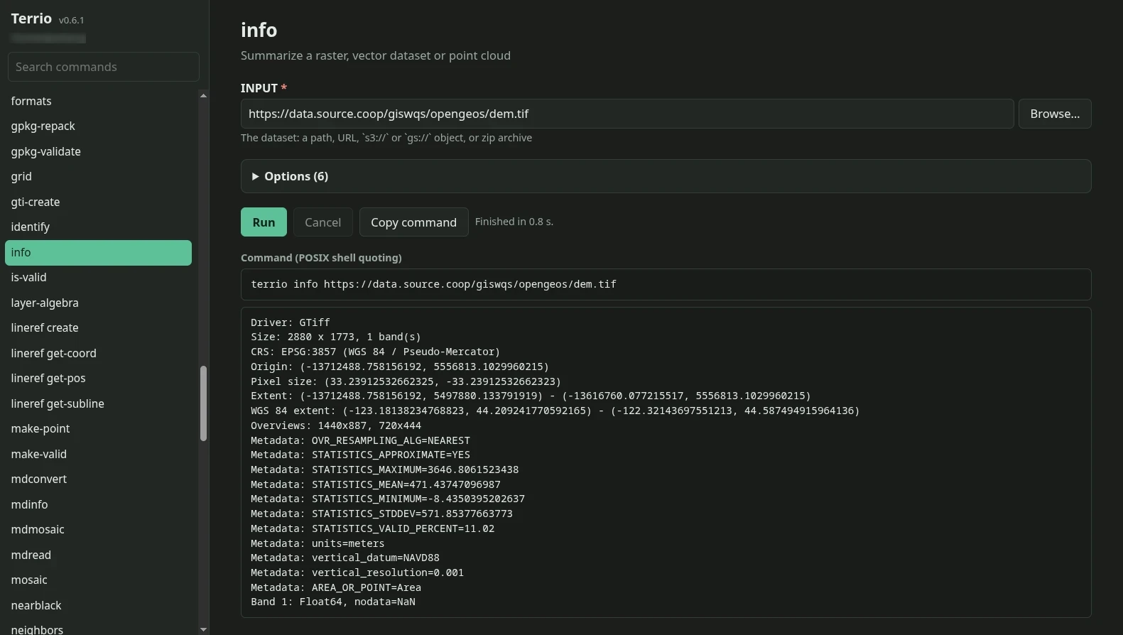
terrio ui serves the same commands as forms in your browser, from your own computer:
terrio ui                        # opens your browser
terrio ui --port 8080 --no-open  # prints the address instead
Every command and option gets a form, generated from the catalog of the binary you run. Pick files
with the built-in file browser or enter a URL, run or cancel the command, read its output, and copy
the equivalent command line into a script. On preview, Open map opens the dataset in a
pan-and-zoom map in a new tab (as terrio view does). The server
listens on 127.0.0.1 only and runs commands with your permissions, so treat its printed address,
which contains a random token, as a password (see ui).
Library
For coordinate transformations without raster/vector I/O, use the standalone
terrio-crs crate. Terrio uses the same engine
through its existing terrio::crs interface.
let ds = terrio::open("countries.gpkg")?;
println!("{}", terrio::info::info(&ds, &Default::default()).to_text());

// Cloud Optimized GeoTIFFs are read in place: opening fetches the headers, and a window read
// fetches only the tiles it needs, with HTTP range requests.
let mut cog = terrio::open_raster_lazy("s3://bucket/image.tif")?;
let options = terrio::WindowOptions { bands: vec![1], overview: Some(0) };
let window = cog.read_window(terrio::Window::new(0, 0, 512, 512), &options)?;
# Ok::<(), terrio::Error>(())
Remote reads are configured with environment variables: AWS_ACCESS_KEY_ID,
AWS_SECRET_ACCESS_KEY, AWS_SESSION_TOKEN, AWS_PROFILE, AWS_REGION, AWS_NO_SIGN_REQUEST
and AWS_S3_ENDPOINT for S3; AZURE_STORAGE_ACCOUNT and AZURE_STORAGE_SAS_TOKEN for Azure;
TERRIO_HTTP_TIMEOUT, TERRIO_HTTP_MAX_RETRY and TERRIO_HTTP_LOG (and more, see the http
module) for HTTP.
Datasets can also be opened from bytes and written to bytes (terrio::memory), for data
already in memory and for WebAssembly, which has no file system.
An optional GDAL backend (the gdal cargo feature, off by default, and a C dependency)
opens what terrio has no driver for (HDF4, NITF and the rest of GDAL's formats)
into the same data model, and writes rasters with GDAL's drivers: terrio::open("GDAL:file.hdf"),
terrio info --driver gdal, or a plain path when terrio's own drivers cannot open it.
Every driver is on by default; each family of them is a cargo feature that can be turned off,
for a smaller dependency tree and WebAssembly module: cad (DWG and DXF), xlsx, parquet, remote (URLs and object
storage), netcdf-hdf5, sqlite (GeoPackage), tiles (MBTiles, PMTiles, MVT), avif, zarr,
jp2, grib, flatgeobuf, osm, pointcloud, lerc, lzma and hecras (HEC-RAS geometry and
plan HDF files). GeoTIFF and COG, the plain raster
and vector formats, the CRS engine and the operations are always built. A COG writer, say,
needs only:
terrio = { version = "0.9", default-features = false, features = ["geotiff"] }
Point clouds are read into columns, one typed vector per dimension (terrio::pointcloud):
use terrio::pointcloud::{self, PointFilter, PointReadOptions};

// A COPC file is read in place: only the octree nodes in the bounds, down to level 4, are fetched.
let mut lidar = pointcloud::open_points("https://host/lidar.copc.laz")?;
let filter = PointFilter { bounds: Some([637000.0, 851000.0, 637500.0, 851500.0]), classes: vec![2], ..Default::default() };
let ground = lidar.read(&PointReadOptions { filter, max_level: Some(4), ..Default::default() })?;
let z = ground.coords("z").unwrap();
pointcloud::write_points(&ground, "ground.laz", &Default::default())?;
let options = pointcloud::grid::GridOptions { resolution: 1.0, ..Default::default() };
let dtm = pointcloud::grid::grid(&ground, &options)?; // a RasterDataset
# Ok::<(), terrio::Error>(())
LAZ compression comes from the pure-Rust laz crate (the codec of
laspy's lazrs backend); terrio reads and writes the LAS container, extra bytes, CRS records and
COPC octrees itself.
Python
pip install terrio
# or, from conda-forge, with either of
conda install -c conda-forge terrio
mamba install -c conda-forge terrio
The operations (convert, translate, warp, mosaic, rasterize, polygonize, dem,
calc, proximity, sieve, fill_nodata, viewshed, zonal_stats and more) take the
command-line options as keyword arguments; render renders datasets as PNG bytes and rasters
display as inline PNGs in Jupyter notebooks. See python/README.md.
rasterio scripts run with an import change, import terrio.rio as rasterio: datasets, windows,
CRSs, features, warping, merging, masking and memory files follow rasterio's API, compared with
rasterio on real files. See Coming from rasterio.
terrio.xarray is rioxarray's API without installing GDAL (pip install "terrio[xarray]"):
terrio.xarray.open_rasterio and xr.open_dataset(path, engine="terrio") open rasters lazily
(remote COGs fetch only the tiles a window needs, chunked with dask), and the .terrio accessor
has rioxarray's .rio methods (clip_box, clip, reproject, reproject_match, pad_box,
to_raster...), compared with rioxarray on real files. See
xarray.
To build the Linux wheel for glibc 2.28 and later (manylinux_2_28) without Docker, run
scripts/build_wheel_manylinux_2_28.sh [OUT_DIR] with Rust and pip install "maturin[zig]": the
wheel lands in python/dist by default, and only if it needs no newer glibc and holds no path of
the build machine.
JavaScript
The terrio-js npm package is the library compiled to WebAssembly, for browsers and Node.js:
import init, { open, readPoints, transformPoints } from "terrio-js";

await init();
const dem = open(new Uint8Array(await (await fetch("dem.tif")).arrayBuffer()), "dem.tif");
dem.info();                                   // the summary `terrio info --json` prints
const band = dem.readBand(1);                 // a Float32Array, Uint8Array...
const roads = open(geojsonBytes, "roads.geojson");
const fgb = roads.toBytes("roads.fgb", { tSrs: "EPSG:3857" });
const ground = readPoints(lazBytes, "tile.laz", { classes: [2] });   // LAS, LAZ, COPC
ground.get("z");                              // a Float64Array
See js/README.md for the formats available in WebAssembly.
Testing against GDAL
scripts/fetch_test_data.sh downloads real-world files (Natural Earth, USGS 3DEP, Sentinel-2,
NASA ECOSTRESS and OPERA products, and more) and derives copies in other formats with GDAL.
scripts/conformance.py runs every comparison below and writes the conformance report
(docs/conformance.md, per format and operation: cases identical to GDAL, within tolerance or
different):
TERRIO_TEST_DATA=../terrio-data cargo test             # tests with values checked against GDAL
python scripts/compare_with_gdal.py ../terrio-data     # compare every file's summary with GDAL's
python scripts/compare_with_gdal.py --roundtrip ../terrio-data countries.geojson fgb gpkg shp
                                                       # convert with terrio, compare GDAL's reading
python scripts/raster_roundtrip.py                     # raster drivers: GDAL writes, terrio reads, and back
python scripts/compare_windows_with_gdal.py local ../terrio-data  # windowed and overview reads
python scripts/compare_windows_with_gdal.py remote     # the same on public COGs, with bytes fetched
cargo test -- --ignored                                # tests that read public cloud files
python scripts/compare_vector_ops_with_gdal.py ../terrio-data  # convert options, rasterize, polygonize
python scripts/compare_processing_with_gdal.py ../terrio-data  # centroids, singleparts, vertices, footprints, sampling
python scripts/compare_topology_with_gdal.py ../terrio-data  # buffer, overlay, dissolve, validity, repair and cleanup
python scripts/compare_raster_analysis_with_gdal.py ../terrio-data  # contours, zonal statistics and SQL
python scripts/compare_ops_with_gdal.py ../terrio-data # compare translate, warp and mosaic with GDAL's tools
python scripts/compare_dem_calc_with_gdal.py ../terrio-data  # dem, calc, proximity and sieve vs GDAL
python scripts/compare_stac_geozarr.py stac            # STAC footprints and STACIT mosaics vs GDAL (Earth Search)
python scripts/compare_stac_geozarr.py stacta ../terrio-data  # STACTA tiled assets vs GDAL's driver
python scripts/compare_stac_geozarr.py geozarr ../terrio-data  # GeoZarr stores read by GDAL and rioxarray
python scripts/compare_remote_zarr.py                  # public cloud Zarr stores read in place vs GDAL and xarray
python scripts/compare_tiles_with_gdal.py ../terrio-data  # PMTiles, MBTiles and MVT vs GDAL's drivers
python scripts/compare_pointclouds.py ../terrio-data   # point clouds: every value vs laspy, headers, COPC
                                                       # queries, grids and reprojection vs PDAL
cd python && TERRIO_TEST_DATA=../../terrio-data pytest # Python bindings, arrays compared with osgeo.gdal's
TERRIO_TEST_DATA=../terrio-data node --test js/tests/node.test.mjs  # WebAssembly build (after wasm-pack build, see js/)
TERRIO_TEST_DATA=../terrio-data cargo test --release --test epsg_accuracy -- --nocapture
                                                       # every EPSG CRS's transformations against GDAL's
Layout
Path
Contents
crates/terrio
The library
crates/terrio-crs
Standalone coordinate systems, transformations and datum grids
crates/terrio-cli
The terrio command-line tool
python
Python bindings (PyO3, NumPy), the terrio package on PyPI
js
WebAssembly bindings (wasm-bindgen), the terrio-js package on npm
See ROADMAP.md for what is planned and in what order.
New to Rust? Contributing walks you through a first change.
Acknowledgements
terrio builds on the work of many projects and their authors, who hold the copyright in the code
and data terrio adapts from them:
whitebox_next_gen by John Lindsay, whose
pure-Rust format libraries (wbraster, wbvector, wbprojection) terrio began on.
GDAL, by Frank Warmerdam, Even Rouault and hundreds of contributors over more
than twenty-five years. terrio's commands, options and much of its behavior follow GDAL's; many
of its algorithms and drivers are ports of GDAL code (contours, nodata filling, gridding,
overviews, pansharpening, the GRIB and SRTMHGT drivers and more, each attributed in
NOTICE); and GDAL is the reference it is tested against and its optional backend.
If terrio is useful to you, please consider
sponsoring GDAL.
PROJ and PDAL, with GDAL the reference terrio tests
against; its projections are ported from PROJ, its point cloud filters follow PDAL's (the cloth
simulation filter of Zhang et al., 2016, is a port of the CSF code PDAL vendors).
The JTS Topology Suite, the source of terrio's
simplification, hull and tile-validity ports; GEOS, their executable
behavior reference; and GeoRust's geo, which
its vector processing is built on.
rasterio, xarray and
rioxarray, whose APIs the Python package follows and
whose code parts of it are adapted from.
The pure-Rust crates terrio reads and writes its formats with, among them tiff, png,
jpeg-decoder, openjp2, rusty_av1d, jxl-oxide, lerc-reader, flatgeobuf, Apache Arrow and
Parquet, netcdf-reader, hdf5-reader, laz and e57; and clap, rayon, serde, PyO3 and
wasm-bindgen.
If you use terrio in your work, please cite it. terrio is archived on Zenodo, which mints a DOI for every release. The concept DOI below always resolves to the latest version.
Wu, Q., Fitzgerald, M., & Morales Sanchez, G. (2026). terrio: Pure-Rust geospatial raster, vector and point cloud data I/O. Zenodo. https://doi.org/10.5281/zenodo.23642204
You can also use GitHub's "Cite this repository" button (which reads CITATION.cff) to copy a ready-made APA or BibTeX entry. See the How to Cite page for more formats.
Disclaimer
terrio is primarily built with Claude Opus 5.5, an AI model by
Anthropic, working under human direction and review. Its results are tested against GDAL, PROJ and
PDAL, but check them for your own use, and please report
anything that looks wrong.
License
terrio is released under the MIT License. Much of it is ported or adapted from other
projects, among them GDAL, PROJ and PDAL, and the copyright in that code and data remains with
their authors: Frank Warmerdam, Even Rouault and the GDAL contributors; Gerald Evenden, Frank
Warmerdam, Even Rouault and the PROJ contributors; Hobu, Inc. and the PDAL contributors; and the
authors of JTS, CSF, rasterio, rioxarray and the other projects NOTICE lists with
their licenses.
terrio's EPSG table and datum names (crates/terrio-crs/data/epsg.tsv.zst, datums.tsv.zst) are
derived from the EPSG Geodetic Parameter Dataset, copyright the International
Association of Oil & Gas Producers (IOGP), whose terms of use
permit their redistribution with this attribution; its ESRI table (esri.tsv.zst) from Esri's
projection engine data (Apache-2.0). The
tables were produced with PROJ and GDAL. The projection
formulas in crates/terrio-crs/src/ are ported from PROJ (MIT licence), and the cloth simulation
filter from CSF (Apache-2.0). Coverage-weighted medians adapt exactextract
(Apache-2.0). NOTICE holds the notices of the code and data terrio
adapts, and LICENSE-THIRD-PARTY.md the licenses of the Rust crates
it is built with.







 terrio 是一个纯 Rust 编写的库(附带命令行工具,以及 Python 和 JavaScript/WASM 绑定),用于读取、写入、转换和重投影地理空间栅格、矢量及点云数据。它不依赖任何 C 库,因此只要 Rust 能编译的平台都能用,包括 WebAssembly。